Last active
December 20, 2015 07:49
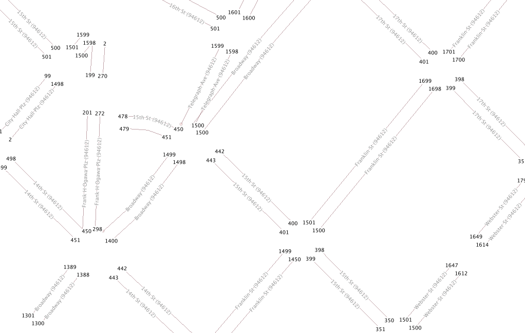
Queries to convert TIGER edges data to labeled address ranges. See: http://mike.teczno.com/img/tiger-ranges.png
This file contains bidirectional Unicode text that may be interpreted or compiled differently than what appears below. To review, open the file in an editor that reveals hidden Unicode characters.
Learn more about bidirectional Unicode characters
| DROP TABLE IF EXISTS tiger_2012_edges_102008; | |
| DROP TABLE IF EXISTS tiger_2012_ends_102008; | |
| CREATE TABLE tiger_2012_edges_102008 | |
| AS | |
| ( | |
| SELECT statefp, countyfp, mtfcc, fullname, | |
| fromadd, toadd, zip, "offset", | |
| -- | |
| -- Snip off first and last 15m of each road to distance it from intersection. | |
| -- | |
| ST_Line_Substring(s.geom, 15 / ST_Length(s.geom), (ST_Length(s.geom) - 15) / ST_Length(s.geom)) AS geom | |
| FROM | |
| ( | |
| SELECT statefp, countyfp, mtfcc, fullname, | |
| lfromadd AS fromadd, ltoadd AS toadd, zipl AS zip, offsetl AS offset, | |
| -- | |
| -- Offset 5m to the left. | |
| -- | |
| ST_OffsetCurve(ST_Transform(ST_GeometryN(geom, 1), 102008), 5) AS geom | |
| FROM tiger_2012_edges | |
| WHERE roadflg = 'Y' | |
| AND lfromadd IS NOT NULL | |
| UNION | |
| SELECT statefp, countyfp, mtfcc, fullname, | |
| rfromadd AS fromadd, rtoadd AS toadd, zipr AS zip, offsetr AS offset, | |
| -- | |
| -- Offset 5m to the right and reverse: "For a negative distance | |
| -- it'll be at the right side and in the opposite direction." | |
| -- http://postgis.refractions.net/docs/ST_OffsetCurve.html | |
| -- | |
| ST_Reverse(ST_OffsetCurve(ST_Transform(ST_GeometryN(geom, 1), 102008), -5)) AS geom | |
| FROM tiger_2012_edges | |
| WHERE roadflg = 'Y' | |
| AND lfromadd IS NOT NULL | |
| ) AS s | |
| -- | |
| -- Limit to those road segments long enough to be meaningful. | |
| -- | |
| WHERE ST_Length(s.geom) > 40 | |
| ); | |
| CREATE TABLE tiger_2012_ends_102008 | |
| AS | |
| ( | |
| SELECT statefp, countyfp, mtfcc, fullname, | |
| add, zip, "offset", p.geom | |
| FROM | |
| ( | |
| SELECT statefp, countyfp, mtfcc, fullname, | |
| fromadd AS add, zip, "offset", | |
| -- | |
| -- Get the first point on the line. | |
| -- | |
| ST_Line_Interpolate_Point(geom, 0) AS geom | |
| FROM tiger_2012_edges_102008 | |
| WHERE ST_GeometryType(geom) = 'ST_LineString' | |
| UNION | |
| SELECT statefp, countyfp, mtfcc, fullname, | |
| toadd AS add, zip, "offset", | |
| -- | |
| -- Get the last point on the line. | |
| -- | |
| ST_Line_Interpolate_Point(geom, 1) AS geom | |
| FROM tiger_2012_edges_102008 | |
| WHERE ST_GeometryType(geom) = 'ST_LineString' | |
| ) AS p | |
| ); |
Sign up for free
to join this conversation on GitHub.
Already have an account?
Sign in to comment