Skip to content

Instantly share code, notes, and snippets.

Registration is open for State of the Map

Registration is now open for the annual US OpenStreetMap conference in San Francisco June 8 & 9. State of the Map US brings two full days of sessions on how OpenStreetMap is being used in the private sector, education, government, and international development, what tools and business models are being built on it, how people are bringing in new users to contribute to the map, and the overall vision of advancing open geodata.

Register today to get the early bird rate of just $75, which is only available for a limited time. We're also offering a one year OpenStreetMap US chapter members for just $10 - a 50% discount - for people attending State of the Map.

Submit a session

<!DOCTYPE html>
<html>
<head>
<script src='http://api.tiles.mapbox.com/mapbox.js/v0.6.7/mapbox.js'></script>
<link href='http://api.tiles.mapbox.com/mapbox.js/v0.6.7/mapbox.css' rel='stylesheet' />
<style>
body { margin:0; padding:0; }
#map { position:absolute; top:0; bottom:0; width:100%; }
</style>
</head>
@lxbarth
lxbarth / index.html
Last active December 16, 2015 05:59 — forked from jfirebaugh/index.html
<!DOCTYPE html>
<html>
<head>
<title>New York City Neighborhoods</title>
<meta charset="utf-8" />
<meta name="viewport" content="width=device-width, initial-scale=1.0">
<html>
<head>
@lxbarth
lxbarth / index.html
Last active December 16, 2015 05:59 — forked from jfirebaugh/index.html
<!DOCTYPE html>
<html>
<head>
<title>New York City Neighborhoods</title>
<meta charset="utf-8" />
<meta name="viewport" content="width=device-width, initial-scale=1.0">
<html>
<head>
<!DOCTYPE html>
<html>
<head>
<meta charset="utf-8" />
<meta name="viewport" content="width=device-width, initial-scale=1.0">
<html>
<head>
<link href='http://api.tiles.mapbox.com/mapbox.js/v1.0.0/mapbox.css' rel='stylesheet' />
<script src='http://api.tiles.mapbox.com/mapbox.js/v1.0.0/mapbox.js'></script>
<script src='nycneighborhoods.js'></script>
@lxbarth
lxbarth / index.html
Last active December 21, 2015 15:18 — forked from e-n-f/index.html
<!DOCTYPE html>
<html>
<head>
<meta name='viewport' content='width=device-width, initial-scale=1.0, maximum-scale=1.0, user-scalable=no' />
<script src='http://api.tiles.mapbox.com/mapbox.js/v1.3.1/mapbox.js'></script>
<link href='http://api.tiles.mapbox.com/mapbox.js/v1.3.1/mapbox.css' rel='stylesheet' />
<!--[if lte IE 8]>
<link href='http://api.tiles.mapbox.com/mapbox.js/v1.3.1/mapbox.ie.css' rel='stylesheet' >
<![endif]-->
<style>

Mapping Monsters

This is just a demo to show how forking works. Done!

Replete with monsters and robots, our new video shows how social maps are - and are inside every app. I hashed out a storyboard - visually representing the points we aimed to highlight took some trial and error, so everything started on paper - specifically notecards on which we had quickly drawn the ideas for each individual shot.

notecards

I arranged shots into cohesive scenes that flowed from one to another. after locking down the story, I got to start doing my favorite part of an animated project: everything.

Mapeando mi vecindad

Luis, Edith haremos una pausa en trazado de los Edificios en San Francisco. Esta pausa es para que ustedes puedan hacer algo diferente, pueden trabajar en sus vecindades o los lugares donde viven, será divertido para ustedes trabajar en los lugares donde más conocen, y que disfruten mapeando.

Ejemplo:

@lxbarth
lxbarth / 0_reuse_code.js
Last active August 29, 2015 14:17
Here are some things you can do with Gists in GistBox.
// Use Gists to store code you would like to remember later on
console.log(window); // log the "window" object to the console

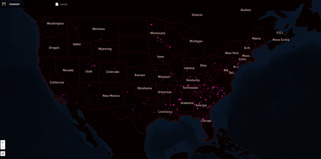
XX,000 US roads added and aligned

Since MONTH YEAR our team has aligned XX,000 roads in the United States. For this process we use fresh US government TIGER data (for a background read Eric Fischer's blog post) to show where OpenStreetMap data is out of date, then we trace from imagery as needed and use road names from TIGER.

Here's the map showing the extent of the issue. Pink lines are the progress over US. Full interactive map.

![]()