Skip to content

Instantly share code, notes, and snippets.

Mapping Monsters

This is just a demo to show how forking works. Done!

Replete with monsters and robots, our new video shows how social maps are - and are inside every app. I hashed out a storyboard - visually representing the points we aimed to highlight took some trial and error, so everything started on paper - specifically notecards on which we had quickly drawn the ideas for each individual shot.

notecards

I arranged shots into cohesive scenes that flowed from one to another. after locking down the story, I got to start doing my favorite part of an animated project: everything.

Mapeando mi vecindad

Luis, Edith haremos una pausa en trazado de los Edificios en San Francisco. Esta pausa es para que ustedes puedan hacer algo diferente, pueden trabajar en sus vecindades o los lugares donde viven, será divertido para ustedes trabajar en los lugares donde más conocen, y que disfruten mapeando.

Ejemplo:

@lxbarth
lxbarth / 0_reuse_code.js
Last active August 29, 2015 14:17
Here are some things you can do with Gists in GistBox.
// Use Gists to store code you would like to remember later on
console.log(window); // log the "window" object to the console

260 309 US roads added and aligned

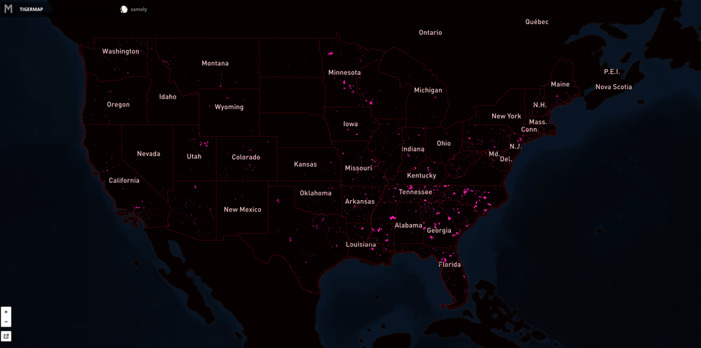
Since SEPTEMBER 2012 our team has aligned 260 309 roads in the United States. For this process we use fresh US government TIGER data (for a background read Eric Fischer's blog post) to show where OpenStreetMap data is out of date, then we trace from imagery as needed and use road names from TIGER.

Here's the map showing the extent of the issue. Pink lines are the progress over US. Full interactive map.

Reviewer notes of edition file 968 (2015-05-08)

user:ramyaragupathy

Incorrect identification of unclassified road

user:Rub21

Tagging of service roads

Por fin en Ayacucho!

Al fin en Ayacucho!

Acabo de mudarme desde Lima a Ayacucho. A partir de Lunes esta semana estaré trabjando tiempo completo junto el equipo aquí en la oficina en Ayacucho.

Me gusta estar aqui en la Pueblo Natal, me gusta mucho trabajar en Ayacucho por su hermoso clima y sus paisajes.

Estoy muy entusiasmado de incorporarme al equipo de Ayacucho, vengo para Aprender y Trabajar con todos mis compañeros.

@lxbarth
lxbarth / ed-about.md
Created January 20, 2012 16:53 — forked from ian29/ed-about.md

About this map

School Performance in America

This map contains the latest available data on graduation rates, math and reading performance for the time between 2007 and 2010. This is data that has been published by the Department of Education continuously since [YEAR], for the first time it is made available through an easy to explore interface and as download in an open format.

Sharing the map

At any time, you can grab a snippet of the map and embed it in another web site - just like a YouTube video. The embed will maintain the exact location you have navigated to.

@lxbarth
lxbarth / webfoundationmaps.md
Created February 14, 2012 12:24 — forked from davejohn/webfoundationmaps.md
Webfoundatation - TED maps

Maps of web index indicators

Web users as percentage of population, 2010

Change in web users 2007 to 2010

Datos SITEL de Jalisco para OpenStreetMap

Datos de Carretera Preparados para Contribución con JOSM

Estamos animados de liberar un conjunto de datos de todas las carreteras en el estado Mexicano de Jalisco, listo para contribuirlos con el editor popular JOSM. Mira el repositorio osm-jalisco para bajar los datos y aprender como empezar.

roads tilemill

Una prestación estilizada en TileMIll

@lxbarth
lxbarth / geojson-tiles.js
Created November 2, 2012 23:33 — forked from glenrobertson/TileLayer.GeoJSON.js
GeoJSON Leaflet Tile Layer
// Load tiled GeoJSON and merge into single geojson hash.
// Requires jQuery for jsonp.
L.TileLayer.GeoJSON = L.TileLayer.extend({
data: null,
_addTile: function(tilePoint, container) {
this._loadTile(null, tilePoint);
},
_loadTile: function (tile, tilePoint) {
var layer = this;
$.ajax({