Skip to content

Instantly share code, notes, and snippets.

@lxbarth
lxbarth / gist:4178351
Created November 30, 2012 20:25 — forked from tristen/gist:4172652

layout: blog category: blog published: true title: "Mapas Dinámicos Rápidos con OpenStreetMap, MapBox.js y Google Spreadsheets" subtitle: "In time for Desarrollando América Latina: an example of quickly building a geo application with MapBox Streets, MapBox.js and Google Spreadsheets" permalink: /blog/aplicacion-mapas-rapido image: http://farm9.staticflickr.com/8210/8224404737_523aca1954_o.jpg tags:

  • Ruben Lopez Mendoza

XX,000 US roads added and aligned

Since MONTH YEAR our team has aligned XX,000 roads in the United States. For this process we use fresh US government TIGER data (for a background read Eric Fischer's blog post) to show where OpenStreetMap data is out of date, then we trace from imagery as needed and use road names from TIGER.

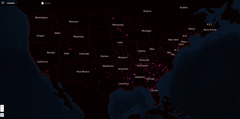
Here's the map showing the extent of the issue. Pink lines are the progress over US. Full interactive map.

![]()

A quarter million US roads added and aligned

Since September 2012 our team has aligned 260,309 roads in the United States. For this process we use fresh US government TIGER data (for a background read Eric Fischer's blog post) to show where OpenStreetMap data is out of date, then we trace from imagery as needed and use road names from TIGER.

Here's the map showing the extent of the issue. Pink lines are the progress over US. Full interactive map.

We continue our work on TIGER with @MateoV's recent analysis that focuses on TIGER issues in areas with high Twitter traffic, missing roads, naming issues and road lengths ov

A quarter million US roads added and aligned

Since September 2012 our team has aligned 260,309 roads in the United States. For this process we use fresh US government TIGER data to show where OpenStreetMap data is out of date, then we trace from imagery as needed and use road names from TIGER. (For a background on TIGER data in OpenStreetMap read Eric Fischer's blog post).

Here's the map showing the extent of the issue. Pink lines are the progress over US. Full interactive map.

We continue our work on TIGER with @MateoV's recent analysis that further focuses our TIGER work. This analysis looks only at areas with high Twitter

Mapbox in Mapgive's Workshop in Cusco-Peru

Last week Ruben and I took part in a workshop in Cuzco with Mikel and Erika from MapGive / US State Department. This Workshop was part of the Cusco Secondary Cities Project. Mikel led the workshop with a translator and Erika, Ruben and I jumped in with helping people hands on through the exercises.

There were four learning processes involved in the workshop;

  • Data collection using OpenMapkit, Fieldpaper and Mapillary
  • Adding collected data to OpenStreetMap
  • Extracting data from OpenstreetMap
  • Using extracted data in Cuscogeonode and Mapbox.com
@lxbarth
lxbarth / en.md
Created March 13, 2012 18:38 — forked from ian29/en.md

Dear RECIPIENT NAME,

In recent weeks we have made good progress in adding missing parts of CITY to OpenStreetMap [2]. If you haven't heard of OpenStreetMap before, it is like a WikiPedia of maps, providing a comprehensive, open map of the world [3] for anyone to use.

From your website I have seen that you manage street name information [4]. We would love to contribute it to OpenStreetMap to further complete the data of CITY, but we have questions around the licensing of this data.

What are the conditions under which you make street name data and other geo data available?

If you have any specific questions, I'd be happy to get on the phone with you and explain more.

@lxbarth
lxbarth / PiuraWorkshopHeyPost.md
Last active February 22, 2016 17:34 — forked from mikelmaron/PiuraWorkshopHeyPost.md
Mapbox in Mapgive's Workshop in Piura-Peru

Mapbox in Mapgive's Workshop in Piura, Peru

image Before - After Map of Piura

Last week, Ruben and I helped lead an OpenStreetMap workshop in Piura - Perú, set up by Tom Gertin from MapGive/US State departament. This event was promoted by Embassy Lima, MapGive, Piura University and Regional Goverment of Piura.

As the local Spanish speaking OpenStreetMap experts we walked attendees through mapping techniques and got them excited about the project. The workshop helps to grow the OpenStreetMap community in Peru, introduces attendees to Mapbox and helps build our relationship with the US Department of State and the Lima Embassy around OpenStreetMap and MapGive.

Bui

@lxbarth
lxbarth / index.html
Last active December 21, 2015 15:18 — forked from e-n-f/index.html
<!DOCTYPE html>
<html>
<head>
<meta name='viewport' content='width=device-width, initial-scale=1.0, maximum-scale=1.0, user-scalable=no' />
<script src='http://api.tiles.mapbox.com/mapbox.js/v1.3.1/mapbox.js'></script>
<link href='http://api.tiles.mapbox.com/mapbox.js/v1.3.1/mapbox.css' rel='stylesheet' />
<!--[if lte IE 8]>
<link href='http://api.tiles.mapbox.com/mapbox.js/v1.3.1/mapbox.ie.css' rel='stylesheet' >
<![endif]-->
<style>
<!DOCTYPE html>
<html>
<head>
<meta charset="utf-8" />
<meta name="viewport" content="width=device-width, initial-scale=1.0">
<html>
<head>
<link href='http://api.tiles.mapbox.com/mapbox.js/v1.0.0/mapbox.css' rel='stylesheet' />
<script src='http://api.tiles.mapbox.com/mapbox.js/v1.0.0/mapbox.js'></script>
<script src='nycneighborhoods.js'></script>
@lxbarth
lxbarth / index.html
Last active December 16, 2015 05:59 — forked from jfirebaugh/index.html
<!DOCTYPE html>
<html>
<head>
<title>New York City Neighborhoods</title>
<meta charset="utf-8" />
<meta name="viewport" content="width=device-width, initial-scale=1.0">
<html>
<head>