Update your path to the Xcode dev tools:
sudo ln -s /Applications/Xcode.app/Contents/Developer /Developer
Then set your xcode folder:
xcode-select -switch /Developer
And then you can run the build-webkit tool from the Tools folder:
Update your path to the Xcode dev tools:
sudo ln -s /Applications/Xcode.app/Contents/Developer /Developer
Then set your xcode folder:
xcode-select -switch /Developer
And then you can run the build-webkit tool from the Tools folder:
| #import <Foundation/Foundation.h> | |
| @interface A: NSObject | |
| @end | |
| @implementation A | |
| void pileOfPoo(id self, SEL _cmd) { | |
| NSLog(@"💩"); | |
| } |
| // Note: have not tested this - but I think it should work! | |
| function cameraWin(picture){ | |
| var theCanvas = document.getElementById('theCanvas'); | |
| var ctx = theCanvas.getContext('2d'); | |
| var theImage = new Image(); | |
| theImage.src = "data:image/jpeg;base64,"+picture; | |
| ctx.drawImage(theImage, 0, 0); |
| #------------------------------------------------------------------------------- | |
| # Makefile for Cordova devs for iOS | |
| #------------------------------------------------------------------------------- | |
| # Use `make help` for more information. | |
| #------------------------------------------------------------------------------- | |
| # This Makefile assumes you have the following subdirectories in the same | |
| # directory as this makefile, presumably git clones of the apache git repos: | |
| # - incubator-cordova-ios | |
| # - incubator-cordova-js | |
| # - incubator-cordova-mobile-spec |
| #!/bin/sh | |
| # Script for managing build and version numbers using git and agvtool. | |
| # Change log: | |
| # v1.0 18-Jul-11 First public release. | |
| # v1.1 29-Sep-12 Launch git, agvtool via xcrun. | |
| version() { |
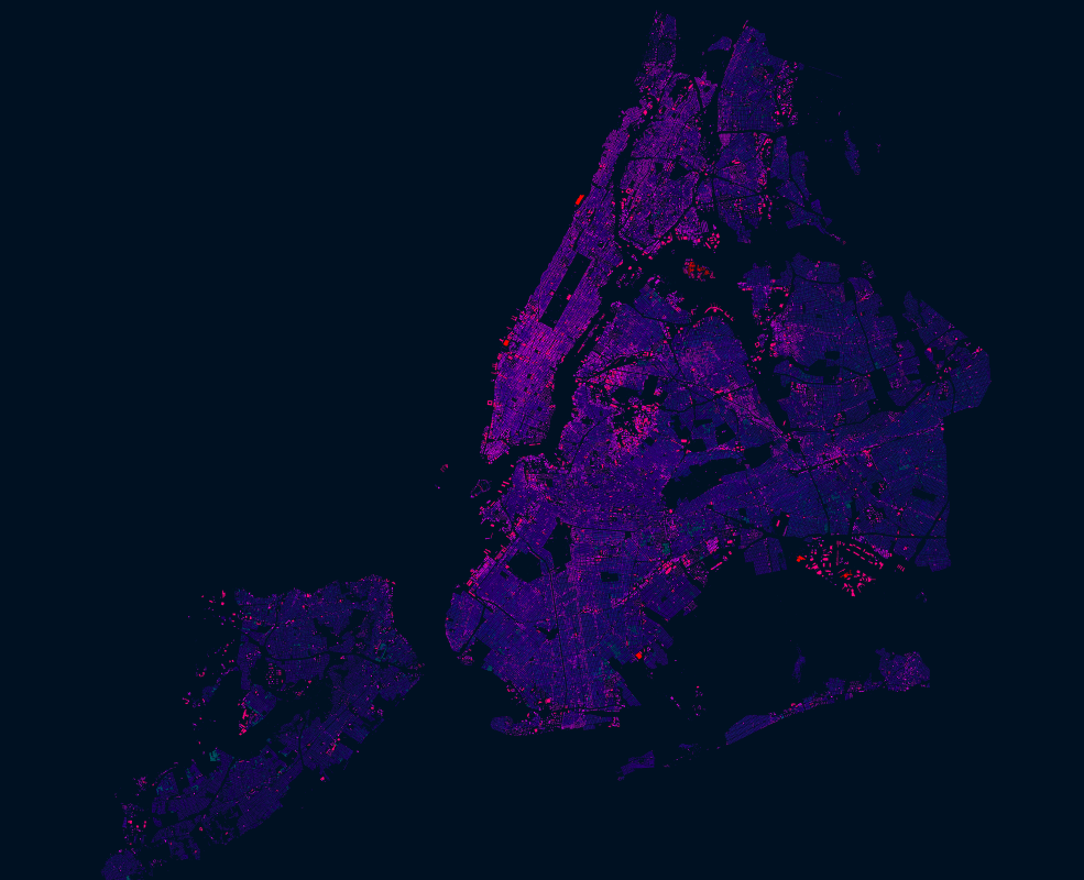
NYC had an import of over 1 million building footprints and 900,000 addresses in 2014 from the New York City Department of Information Technology and Telecommunications (DoITT). The DoITT GIS releases an updated shapefile of the footprints every quarter, and the latest version can be accessed here: Building footprints | Address points
Open datasets like these are a great opportunity to explore how OSM can be used as a bridge between authoritative information and that crowdsourced by citizens. Two years after the import, it is interesting to see how the OSM data compares with the latest official footprints. The interesting questions to ask is:
| recursive_index.pl : Sample Description |
#Mac OS X
| use first; | |
| create table teaching ( | |
| instr_name varchar(15), | |
| course varchar(10) | |
| ); | |
| -- NOTE: You will need to update the path to match where instr-classes.csv is. | |
| load data local infile 'D:/Users/Phil/Downloads/instr-classes.csv' | |
| into table teaching | |
| fields terminated by ','; |