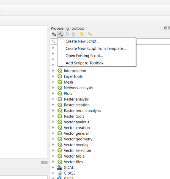
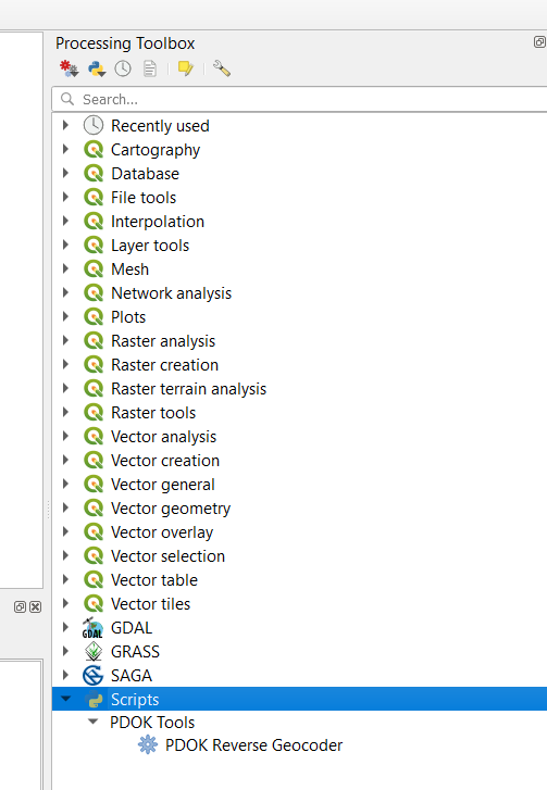
|
#!/usr/bin/env python3 |
|
# -*- coding: utf-8 -*- |
|
|
|
"""pdok-geocoder.py: QGIS Processing tool for geocoding with the PDOK \ |
|
Locatieserver. Tested with QGIS version 3.16, but will probably work with any \ |
|
3.X version.""" |
|
|
|
# MIT License |
|
|
|
# Copyright (c) 2021 Anton Bakker |
|
|
|
# Permission is hereby granted, free of charge, to any person obtaining a copy |
|
# of this software and associated documentation files (the "Software"), to deal |
|
# in the Software without restriction, including without limitation the rights |
|
# to use, copy, modify, merge, publish, distribute, sublicense, and/or sell |
|
# copies of the Software, and to permit persons to whom the Software is |
|
# furnished to do so, subject to the following conditions: |
|
|
|
# The above copyright notice and this permission notice shall be included in all |
|
# copies or substantial portions of the Software. |
|
|
|
# THE SOFTWARE IS PROVIDED "AS IS", WITHOUT WARRANTY OF ANY KIND, EXPRESS OR |
|
# IMPLIED, INCLUDING BUT NOT LIMITED TO THE WARRANTIES OF MERCHANTABILITY, |
|
# FITNESS FOR A PARTICULAR PURPOSE AND NONINFRINGEMENT. IN NO EVENT SHALL THE |
|
# AUTHORS OR COPYRIGHT HOLDERS BE LIABLE FOR ANY CLAIM, DAMAGES OR OTHER |
|
# LIABILITY, WHETHER IN AN ACTION OF CONTRACT, TORT OR OTHERWISE, ARISING FROM, |
|
# OUT OF OR IN CONNECTION WITH THE SOFTWARE OR THE USE OR OTHER DEALINGS IN THE |
|
# SOFTWARE. |
|
|
|
__author__ = "Anton Bakker" |
|
__copyright__ = "Copyright 2021, Anton Bakker" |
|
__license__ = "MIT" |
|
__version__ = "1.0.0" |
|
__maintainer__ = "Anton Bakker" |
|
__email__ = "anton.bakker@kadaster.nl" |
|
__date__ = "2021-02-05" |
|
|
|
from qgis.PyQt.QtCore import QCoreApplication, QVariant |
|
from qgis.core import ( |
|
QgsProject, |
|
QgsProcessing, |
|
QgsField, |
|
QgsGeometry, |
|
QgsPointXY, |
|
QgsWkbTypes, |
|
QgsFeature, |
|
QgsUnitTypes, |
|
QgsFeatureSink, |
|
QgsCoordinateReferenceSystem, |
|
QgsCoordinateTransform, |
|
QgsProcessingAlgorithm, |
|
QgsProcessingException, |
|
QgsProcessingParameterDistance, |
|
QgsProcessingParameterCrs, |
|
QgsProcessingParameterFeatureSource, |
|
QgsProcessingParameterEnum, |
|
QgsProcessingParameterBoolean, |
|
QgsProcessingParameterString, |
|
QgsProcessingParameterNumber, |
|
QgsProcessingParameterFeatureSink, |
|
QgsProcessingParameterField, |
|
) |
|
from qgis import processing |
|
import requests |
|
import json |
|
import re |
|
|
|
|
|
class PDOKGeocoder(QgsProcessingAlgorithm): |
|
""" |
|
This processing tool queries the PDOK Locatieserver fe geocoder service for each point in the input |
|
layer and adds the first result to the target attribute. |
|
""" |
|
|
|
GEOM_TYPE_MAP = { |
|
"weg": QgsWkbTypes.MultiLineString, |
|
"adres": QgsWkbTypes.Point, |
|
"gemeente": QgsWkbTypes.MultiPolygon, |
|
"postcode": QgsWkbTypes.Point, |
|
"woonplaats": QgsWkbTypes.MultiPolygon, |
|
} |
|
|
|
USER_AGENT_HEADER = {"User-Agent": "qgis-pdok-processing-tools"} |
|
|
|
def tr(self, string): |
|
""" |
|
Returns a translatable string with the self.tr() function. |
|
""" |
|
return QCoreApplication.translate("Processing", string) |
|
|
|
def createInstance(self): |
|
# Must return a new copy of your algorithm. |
|
return PDOKGeocoder() |
|
|
|
def name(self): |
|
""" |
|
Returns the unique algorithm name. |
|
""" |
|
return "pdok-geocoder" |
|
|
|
def displayName(self): |
|
""" |
|
Returns the translated algorithm name. |
|
""" |
|
return self.tr("PDOK Geocoder") |
|
|
|
def group(self): |
|
""" |
|
Returns the name of the group this algorithm belongs to. |
|
""" |
|
return self.tr("PDOK Tools") |
|
|
|
def groupId(self): |
|
""" |
|
Returns the unique ID of the group this algorithm belongs |
|
to. |
|
""" |
|
return "pdok-tools" |
|
|
|
def shortHelpString(self): |
|
""" |
|
Returns a localised short help string for the algorithm. |
|
""" |
|
return self.tr( |
|
'This is processing tool queries the PDOK Locatieserver (LS) geocoder service for each\ |
|
feature in the input layer. The geometry returned by the LS, \ |
|
based on the target attribute of the feature, will be added to the output layer.\ |
|
Layers without geometry such as csv and xslx based layers are also suported. \ |
|
Existing attributes will be overwritten in the output layer. To query based on\ |
|
postal code and house number, ensure your input data conforms to this format: \ |
|
"{postal-code} {house-nr}" (note the space separating the postal code en the house number).\ |
|
So for example "1071XX 1". See the LS documentation: \ |
|
https://github.com/PDOK/locatieserver/wiki/API-Locatieserver\n\ |
|
Parameters:\n\n\ |
|
- Input layer: for each feature the LS geocoder service will be queried\n\ |
|
- Attribute to geocode: attribute in input layer to query LS with\n\ |
|
- Geocode result type, default - "adres"\n\ |
|
- Output layer: resulting output layer\n\ |
|
- Target CRS: CRS of the resulting output layer\n\ |
|
- Retrieve actual geometry (instead of centroid), default - false: will return MultiLineString geometry for weg, and MultiPolygon for gemeente en woonplaats. Not applicable to adres and postcode.\n\ |
|
- Add x and Y attribute, default - false: add "x" and "y" attributes to the output layer containing the \ |
|
geometry centroid coordinates\n\ |
|
- Add "weergavenaam" (display name) attribute, default - false: add "weergavenaam" attribute to the output \ |
|
layer, displayname is a field returned by LS.\n\ |
|
- Score treshold, optional: objects returned by the LS geocoder each have a score, \ |
|
to indicate how well they match with the query. Results with a score lower than the treshold \ |
|
are excluded\n\ |
|
' |
|
) |
|
|
|
def initAlgorithm(self, config=None): |
|
""" |
|
Here we define the inputs and outputs of the algorithm. |
|
""" |
|
self.predicates = [ |
|
("adres", self.tr("adres")), |
|
("gemeente", self.tr("gemeente")), |
|
("postcode", self.tr("postcode")), |
|
("weg", self.tr("weg")), |
|
("woonplaats", self.tr("woonplaats")), |
|
] |
|
|
|
self.TARGET_CRS = "TARGET_CRS" |
|
self.INPUT = "INPUT" # recommended name for the main input parameter |
|
self.ADD_XY_FIELD = "ADD_XY_FIELD" |
|
self.SRC_FIELD = "SRC_FIELD" |
|
self.RESULT_TYPE = "RESULT_TYPE" |
|
self.SCORE_TRESHOLD = "SCORE_TRESHOLD" |
|
self.OUTPUT = "OUTPUT" # recommended name for the main output parameter |
|
self.ADD_DISPLAY_NAME = "ADD_DISPLAY_NAME" |
|
self.GET_ACTUAL_GEOM = "GET_ACTUAL_GEOM" |
|
|
|
self.addParameter( |
|
QgsProcessingParameterFeatureSource( |
|
self.INPUT, |
|
self.tr("Input layer"), |
|
types=[QgsProcessing.TypeFile], |
|
) |
|
) |
|
self.addParameter( |
|
QgsProcessingParameterField( |
|
self.SRC_FIELD, |
|
self.tr("Attribute to geocode"), |
|
None, |
|
"INPUT", |
|
) |
|
) |
|
self.addParameter( |
|
QgsProcessingParameterEnum( |
|
self.RESULT_TYPE, |
|
self.tr("Result type to geocode"), |
|
options=[p[1] for p in self.predicates], |
|
defaultValue=0, |
|
optional=False, |
|
) |
|
) |
|
self.addParameter( |
|
QgsProcessingParameterFeatureSink(self.OUTPUT, self.tr("Output layer")) |
|
) |
|
self.addParameter( |
|
QgsProcessingParameterCrs( |
|
self.TARGET_CRS, self.tr("Target CRS"), "EPSG:4326" |
|
) |
|
) |
|
self.addParameter( |
|
QgsProcessingParameterBoolean( |
|
self.GET_ACTUAL_GEOM, |
|
self.tr("Retrieve actual geometry (instead of centroid)"), |
|
False, |
|
) |
|
) |
|
self.addParameter( |
|
QgsProcessingParameterBoolean( |
|
self.ADD_XY_FIELD, self.tr("Add x and Y attribute"), False |
|
) |
|
) |
|
self.addParameter( |
|
QgsProcessingParameterBoolean( |
|
self.ADD_DISPLAY_NAME, |
|
self.tr('Add "weergavenaam" (display name) attribute'), |
|
False, |
|
) |
|
) |
|
self.addParameter( |
|
QgsProcessingParameterNumber( |
|
self.SCORE_TRESHOLD, |
|
self.tr("Score treshold"), |
|
type=QgsProcessingParameterNumber.Double, |
|
defaultValue=None, |
|
optional=True, |
|
minValue=0, |
|
) |
|
) |
|
|
|
def get_geom(self, get_actual_geom, result_type, data, feedback): |
|
""" |
|
Returns a geometry depending on get_actual_geom boolean. |
|
If false: return geom based on "centroide_ll" from the data |
|
If true: retrieve the actual object from the lookup service and |
|
return the geom based on "geometrie_ll" from the lookup response |
|
""" |
|
if not get_actual_geom or result_type in ["adres", "postcode"]: |
|
wkt_point = data["response"]["docs"][0]["centroide_ll"] |
|
return QgsGeometry.fromWkt(wkt_point) |
|
else: |
|
ls_id = wkt_point = data["response"]["docs"][0]["id"] |
|
url = f"https://geodata.nationaalgeoregister.nl/locatieserver/v3/lookup?id={ls_id}&fl=id,geometrie_ll" |
|
feedback.pushInfo(f"INFO: HTTP GET {url}") |
|
response = requests.get(url, headers=PDOKGeocoder.USER_AGENT_HEADER) |
|
if response.status_code != 200: |
|
raise QgsProcessingException( |
|
f"Unexpected response from HTTP GET {url}, response code: {response.status_code}" |
|
) |
|
data = response.json() |
|
if len(data["response"]["docs"]) != 1: |
|
raise QgsProcessingException( |
|
f"Unexpected response body from HTTP GET {url}" |
|
) |
|
wkt_geom = data["response"]["docs"][0]["geometrie_ll"] |
|
return QgsGeometry.fromWkt(wkt_geom) |
|
|
|
def processAlgorithm(self, parameters, context, feedback): |
|
try: |
|
# read out parameters |
|
input_layer = self.parameterAsVectorLayer(parameters, self.INPUT, context) |
|
out_crs = parameters[self.TARGET_CRS] |
|
result_type = [ |
|
self.predicates[i][0] |
|
for i in self.parameterAsEnums(parameters, self.RESULT_TYPE, context) |
|
][0] |
|
score_treshold = parameters[self.SCORE_TRESHOLD] |
|
add_xy_field = parameters[self.ADD_XY_FIELD] |
|
add_display_name = parameters[self.ADD_DISPLAY_NAME] |
|
src_field = parameters[self.SRC_FIELD] |
|
get_actual_geom = parameters[self.GET_ACTUAL_GEOM] |
|
|
|
# start processing |
|
transform = None |
|
fields = input_layer.fields() |
|
field_names = [field.name() for field in fields] |
|
|
|
if add_xy_field: |
|
fields.append(QgsField("x", QVariant.Double)) |
|
fields.append(QgsField("y", QVariant.Double)) |
|
|
|
display_name_att_name = "weergavenaam" |
|
if add_display_name: |
|
fields.append(QgsField(display_name_att_name, QVariant.String)) |
|
|
|
(sink, dest_id) = self.parameterAsSink( |
|
parameters, |
|
self.OUTPUT, |
|
context, |
|
fields, |
|
PDOKGeocoder.GEOM_TYPE_MAP[result_type], |
|
out_crs, |
|
) |
|
|
|
if feedback.isCanceled(): |
|
return {} |
|
|
|
for feature in input_layer.getFeatures(): |
|
query = feature.attribute(src_field) |
|
|
|
url = f"https://geodata.nationaalgeoregister.nl/locatieserver/v3/free?q={query} and type:{result_type}" |
|
match = re.search("([0-9]{4}[A-Za-z]{2})\s(.*)", query) |
|
if match and len(match.groups()) == 2: |
|
postal_code = match.group(1) |
|
house_nr = match.group(2) |
|
url = f"http://geodata.nationaalgeoregister.nl/locatieserver/free?fq=postcode:{postal_code}&fq=huisnummer~{house_nr}*&q=type:{result_type}" |
|
|
|
feedback.pushInfo(f"INFO: HTTP GET {url}") |
|
response = requests.get(url, headers=PDOKGeocoder.USER_AGENT_HEADER) |
|
sc = response.status_code |
|
if response.status_code != 200: |
|
raise QgsProcessingException( |
|
f"Unexpected response from HTTP GET {url}, response code: {response.status_code}" |
|
) |
|
data = response.json() |
|
geom = None |
|
display_name = "" |
|
if len(data["response"]["docs"]) > 0: |
|
if ( |
|
score_treshold != None |
|
and data["response"]["docs"][0]["score"] <= score_treshold |
|
): |
|
geom = None |
|
else: |
|
geom = self.get_geom( |
|
get_actual_geom, result_type, data, feedback |
|
) |
|
display_name = data["response"]["docs"][0]["weergavenaam"] |
|
|
|
if geom: |
|
attrs = feature.attributes() |
|
new_ft = QgsFeature(fields) |
|
|
|
for i in range(len(attrs)): |
|
attr = attrs[i] |
|
field_name = field_names[i] |
|
new_ft.setAttribute(field_name, attr) |
|
|
|
in_crs = QgsCoordinateReferenceSystem.fromEpsgId(4326) |
|
|
|
if out_crs.authid() != "EPSG:4326": |
|
transform = QgsCoordinateTransform( |
|
in_crs, out_crs, QgsProject.instance() |
|
) |
|
geom.transform(transform) |
|
|
|
if add_xy_field: |
|
point_geom = QgsGeometry.asPoint(geom.centroid()) |
|
pxy = QgsPointXY(point_geom) |
|
x = pxy.x() |
|
y = pxy.y() |
|
new_ft.setAttribute("x", x) |
|
new_ft.setAttribute("y", y) |
|
|
|
if add_display_name: |
|
new_ft.setAttribute(display_name_att_name, display_name) |
|
|
|
new_ft.setGeometry(geom) |
|
sink.addFeature(new_ft, QgsFeatureSink.FastInsert) |
|
|
|
if feedback.isCanceled(): |
|
return {} |
|
|
|
results = {} |
|
results[self.OUTPUT] = dest_id |
|
return results |
|
except Exception as e: |
|
raise QgsProcessingException( |
|
f"Unexpected error occured while running PDOKGeocoder: {str(e)}" |
|
) |


