SRCCON 2014 | Al Shaw | @A_L | almshaw@gmail.com
This file: http://j.mp/srccon-raster
-
Shameless plug: SimpleTiles + SimplerTiles now support raster data.
-
SimplerTiles slippy map example:
map = SimplerTiles::Map.new do |m| m.slippy params[:x].to_i, params[:y].to_i, params[:z].to_i m.raster_layer "path/to/geo.tif" end -
SimplerTiles Raster DEMO <--- Image is scene LC80130322014100LGN00 available on the thumb drive, hastily pansharpened in Photoshop

- NYT 2010 Census Explorer
- WaPo Super ZIPs
- Fusion tables, Google Maps API, Mapbox/OpenStreetMap, d3, Landline

(via http://flowingdata.com/2014/07/07/19-maps-that-will-blow-your-mind/)
- Crafting the Blue Marble
- NYPL MapWarper: Manhattan, 1891 Georectified
- Raster to Vector! NYPL Perris Atlas
- PublicLab: Grand Isle, Louisiana mapping
- NYT: Battle for the Baiji Oil Refinery
- NYT: A Rogue State Along Two Rivers
- MapBox: Monitoring Oil Reserves from Space
- Drone pilot finds “river of blood” outside Dallas meatpacking plant
- NASA Earth Observatory: Glacier Retreat near Indonesia's Grasberg Mine
- Mapbox: Cloudless Atlas
- Google Earth Engine + Timelapses
- Raster imagery after a disaster: Hurricane Sandy
When reporting ruins a good story: Georeferencing FEMA's paper flood maps after Weld County, Colo. flooding

- Three kinds of resolution: spatial, temporal, wavelength
- Comparisons:


(via: http://www.geog.ucsb.edu/~jeff/projects/thesis/)
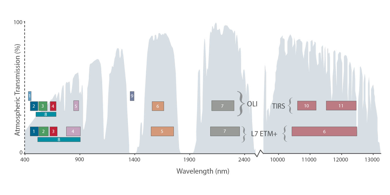
- Landsat 7/8 bands compared
- Common Landsat 8 band combinations
- NDVI: Measuring vegetation. Quick 'n dirty NDVI Python script.
- Pansharpening in Photoshop, Orfeo
- NOAA Historical Charts
- USGS Earth Explorer
- Landsat via Google EarthEngine
- NASA LPDAAC
- Blue Marble (Derived from Modis)
- Emerging private companies: PlanetLab, Skybox, etc.
- Georeference any image you want, using QGIS!
-
Check the geo headers of a file with
gdalinfoDriver: GTiff/GeoTIFF Files: LC80130322014100LGN00_B1.TIF Size is 7661, 7791 Coordinate System is: PROJCS["WGS 84 / UTM zone 18N", GEOGCS["WGS 84", DATUM["WGS_1984", SPHEROID["WGS 84",6378137,298.257223563, AUTHORITY["EPSG","7030"]], AUTHORITY["EPSG","6326"]], PRIMEM["Greenwich",0], UNIT["degree",0.0174532925199433], AUTHORITY["EPSG","4326"]], PROJECTION["Transverse_Mercator"], PARAMETER["latitude_of_origin",0], PARAMETER["central_meridian",-75], PARAMETER["scale_factor",0.9996], PARAMETER["false_easting",500000], PARAMETER["false_northing",0], UNIT["metre",1, AUTHORITY["EPSG","9001"]], AUTHORITY["EPSG","32618"]] Origin = (524085.000000000000000,4582215.000000000000000) Pixel Size = (30.000000000000000,-30.000000000000000) Metadata: AREA_OR_POINT=Point Image Structure Metadata: INTERLEAVE=BAND Corner Coordinates: Upper Left ( 524085.000, 4582215.000) ( 74d42'42.88"W, 41d23'27.98"N) Lower Left ( 524085.000, 4348485.000) ( 74d43'14.63"W, 39d17' 7.42"N) Upper Right ( 753915.000, 4582215.000) ( 71d57'53.48"W, 41d21' 5.12"N) Lower Right ( 753915.000, 4348485.000) ( 72d 3'27.41"W, 39d14'54.75"N) Center ( 639000.000, 4465350.000) ( 73d21'49.68"W, 40d19'37.63"N) Band 1 Block=7661x1 Type=UInt16, ColorInterp=Gray -
Hint: find the EPSG SRS code from Proj string with prj2epsg
-
Hint: reproject coordinates together with
cs2cs, also available online -
Reproject images with
gdalwarpfor band in {4,3,2} do gdalwarp -t_srs EPSG:3857 img_$band.tif img_$band_projected.tif done -
Stitch scenes together with
gdalwarpfor scenes in $(ls) do gdalwarp --config GDAL_CACHEMAX 3000 -wm 3000 $scenes stitched.tif done -
Merge bands together with
gdal_merge.py# preserve nodata gdal_merge.py -n 0 -a_nodata 0 -o out.tiff image1_band1.tiff image1_band2.tif -
Add geographic headers to any TIF with
gdal_edit.pygdal_edit.py -a_srs EPSG:3857 scene.tif -
Manipulate and combine images using
convert, then put geo headers back in withlistgeo# generate a tfw file listgeo -tfw scene.tif -
Do calculations between bands with
gdal_calc.py -
Putting it all together: charlie-loyd.rake based on Charlie Loyd's post.
-
The old fashioned way: Rob Simmon's "How to Make a True-Color Landsat 8 Image"
-
GDAL cheat sheet from Derek Watkins
-
GDAL scripts from Dan Stahlke
- True color (4,3,2) Landsat 8 image of southeast Louisiana

- False color (7,5,3) image of southeast Louisiana to accentuate coastal erosion

- Land loss in Lafitte, La. since 1956


- How to acquire and process data programmatically, to create "real time" raster apps?
- How do we stitch and blend together large amounts of data, especially with cloud cover?
- How can we store and serve massive GeoTIFFs?
- Design/presentation issues: How do we show false color images to readers without being misleading?
- Deciding between vector and raster maps
- Processing your own imagery vs. using Google or Mapbox imagery
- The future of raster - privacy concerns with increased spatial and temporal resolution
- The uncanny valley of sharpening and post-processing: when does an image become an illustration?
- Landsat 8 scenes LC80130322014100LGN00 and LC80140322014187LGN00 (NYC meets Philly <3 <3 <3)