- What is Georeferencing? And Why?
- Ground Control Points.
- Tools. 1. GIMP 2. Inkscape 3. QGIS
- Raster data.
- Process
Sajjad Anwar geohacker
geohacker
/ georeferencing101.md
Last active
February 24, 2021 07:51
Georeferencing 101 - Images to Spatial Data.
Sorry, something went wrong. Reload?
Sorry, we cannot display this file.
Sorry, this file is invalid so it cannot be displayed.
Lorem Ipsum is simply dummy text of the printing and typesetting industry. Lorem Ipsum has been the industry's standard dummy text ever since the 1500s, when an unknown printer took a galley of type and scrambled it to make a type specimen book. It has survived not only five centuries, but also the leap into electronic typesetting, remaining essentially unchanged. It was popularised in the 1960s with the release of Letraset sheets containing Lorem Ipsum passages, and more recently with desktop publishing software like Aldus PageMaker including versions of Lorem Ipsum.
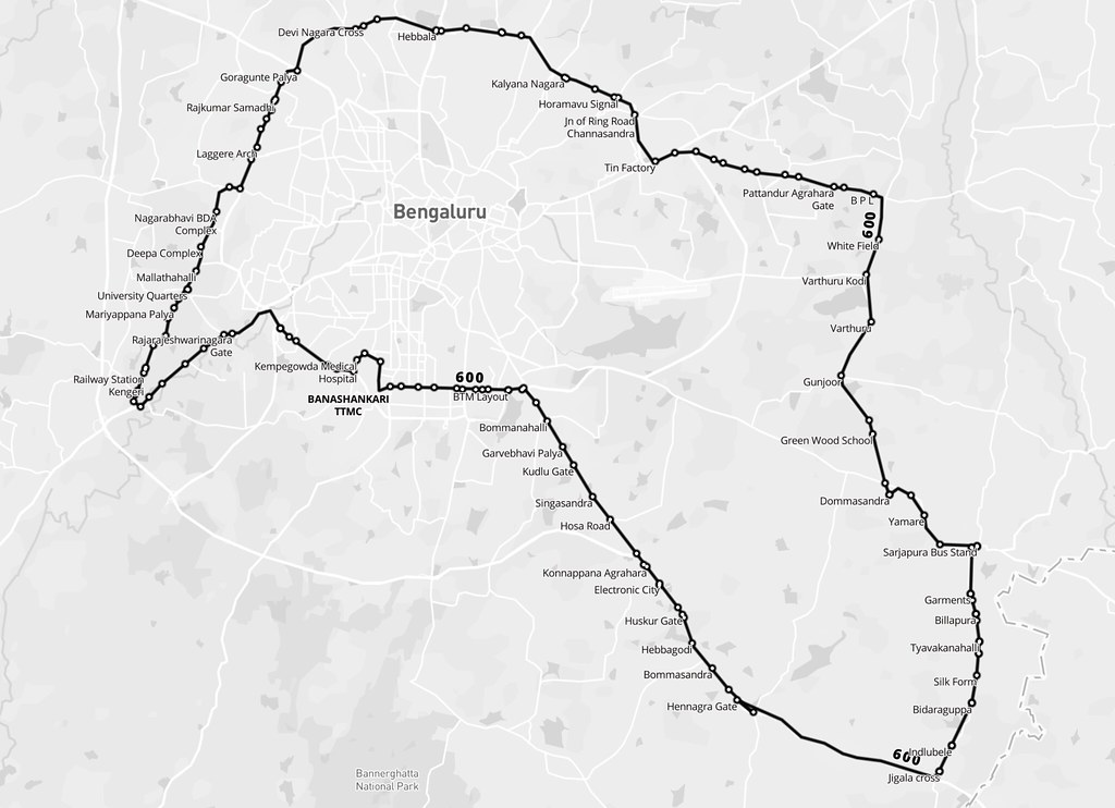
Open Bangalore has been pioneering making several data sets open - including the network of Bangalore Metropolitan Transport Corporation. The BMTC operates over 2000 routes in Bangalore and is the only practical public transit system in the city. Some of us at DataMeet took to time understand this network better by performing some basic analysis.
BMTC is known for its many long routes. Route 600 is the longest, making a roundtrip around the city, covering 117 km in about 5 hours. There are 5 trips a day, and these buses are packed throughout.
geohacker
/ homibhabha.md
Last active
January 2, 2016 16:19
Outline for the session at Homi Bhabha Center, Bombay.
-
Basic intro to web development: 15 mins
-
What happens with an HTTP request
-
10 minute history of web standards / HTML. first page on the internet * Markup language + CSS + Javascript * Browser wars, html 4.0, etc. * From pages to apps - HTML 5 / Web Apps 1.0
-
Evolution of Javascript: 10 mins
-
from "DHTML" tor jQuery to complex web apps and 10,000 javascript frame-works.
Sorry, something went wrong. Reload?
Sorry, we cannot display this file.
Sorry, this file is invalid so it cannot be displayed.
This file contains bidirectional Unicode text that may be interpreted or compiled differently than what appears below. To review, open the file in an editor that reveals hidden Unicode characters.
Learn more about bidirectional Unicode characters
| {"features":[{"id":"V.Jayalakshmi","properties":{"Name":"V.Jayalakshmi","Number of sessions":1,"State":"Tamil Nadu","City ":"Sathyamangalam","geo_longitude":77.276,"geo_latitude":11.5845},"type":"Feature","geometry":{"type":"Point","coordinates":[77.276,11.5845]}},{"id":"Shailendra Singh","properties":{"Name":"Shailendra Singh","Number of sessions":1,"State":"New Delhi","City ":"New Delhi","geo_longitude":77.2159562,"geo_latitude":28.6138967},"type":"Feature","geometry":{"type":"Point","coordinates":[77.2159562,28.6138967]}},{"id":"R.S. Mathur","properties":{"Name":"R.S. Mathur","Number of sessions":1,"State":"New Delhi","City ":"New Delhi","geo_longitude":77.2159562,"geo_latitude":28.6138967},"type":"Feature","geometry":{"type":"Point","coordinates":[77.2159562,28.6138967]}},{"id":"Chandan Borthakur","properties":{"Name":"Chandan Borthakur","Number of sessions":1,"State":"Assam","City ":"Gohpur","geo_longitude":93.6323048,"geo_latitude":26.8879397},"type":"Feature","geometry":{"type":"Point","coordinates":[9 |
geohacker
/ index.html
Last active
December 10, 2015 16:48
— forked from mbostock/.block
This file contains bidirectional Unicode text that may be interpreted or compiled differently than what appears below. To review, open the file in an editor that reveals hidden Unicode characters.
Learn more about bidirectional Unicode characters
| <html> | |
| <head> | |
| <title>Bar Chart</title> | |
| <script type="text/javascript" src="http://github.com/mbostock/d3/raw/v1.8.2/d3.js"></script> | |
| <style type="text/css"> | |
| body { | |
| font: 10px sans-serif; | |
| } |
This file contains bidirectional Unicode text that may be interpreted or compiled differently than what appears below. To review, open the file in an editor that reveals hidden Unicode characters.
Learn more about bidirectional Unicode characters
| var map = new L.Map('map'); | |
| var mapquestUrl = 'http://{s}.mqcdn.com/tiles/1.0.0/osm/{z}/{x}/{y}.png', | |
| subDomains = ['otile1','otile2','otile3','otile4'], | |
| mapquestAttrib = 'Data, imagery and map information provided by <a href="http://open.mapquest.co.uk" target="_blank">MapQuest</a>, | |
| <a href="http://www.openstreetmap.org/" target="_blank">OpenStreetMap</a> and contributors. | |
| var mapquest = new L.TileLayer(mapquestUrl, {maxZoom: 18, attribution: mapquestAttrib, subdomains: subDomains}); |
This file contains bidirectional Unicode text that may be interpreted or compiled differently than what appears below. To review, open the file in an editor that reveals hidden Unicode characters.
Learn more about bidirectional Unicode characters
| var map = new L.Map('map'); | |
| var cloudmadeUrl = 'http://{s}.tile.cloudmade.com/API-KEY/997/256/{z}/{x}/{y}.png', | |
| cloudmadeAttrib = 'Map data © 2011 OpenStreetMap contributors, Imagery © 2011 CloudMade', | |
| cloudmade = new L.TileLayer(cloudmadeUrl, {maxZoom: 18, attribution: cloudmadeAttrib}); |
NewerOlder