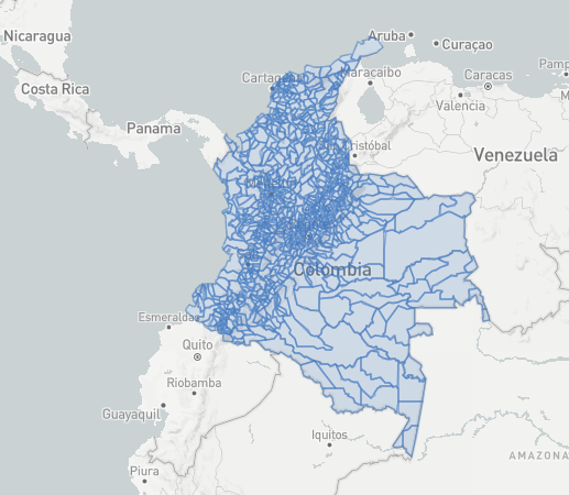
Simple map of Colombia with cities (municipios) and states (departamentos)
GEO Json from Javier Moreno mapa-colombia-js project on github
forked from mbostock's block: New Jersey State Plane
| license: mit |
Simple map of Colombia with cities (municipios) and states (departamentos)
GEO Json from Javier Moreno mapa-colombia-js project on github
forked from mbostock's block: New Jersey State Plane
| <!DOCTYPE html> | |
| <meta charset="utf-8"> | |
| <style> | |
| .tract { | |
| fill: #eee; | |
| } | |
| .tract:hover { | |
| fill: orange; | |
| } | |
| .tract-border { | |
| fill: none; | |
| stroke: #777; | |
| pointer-events: none; | |
| } | |
| .tract-border-state { | |
| fill: none; | |
| stroke: #333; | |
| stroke-width: 1.5px; | |
| pointer-events: none; | |
| } | |
| </style> | |
| <svg width="960" height="550"></svg> | |
| <script src="https://d3js.org/d3.v4.min.js"></script> | |
| <script src="https://d3js.org/topojson.v1.min.js"></script> | |
| <script> | |
| var svg = d3.select("svg"), | |
| width = +svg.attr("width"), | |
| height = +svg.attr("height"), | |
| margin = { top: 20, bottom:20, right: 20, left: 20}; | |
| d3.json("colombia-municipios.json", function(error, data) { | |
| if (error) throw error; | |
| var land = topojson.feature(data, { | |
| type: "GeometryCollection", | |
| geometries: data.objects.mpios.geometries.filter(function(d) { | |
| return (d.id / 10000 | 0) % 100 !== 99; | |
| }) | |
| }); | |
| var landState = topojson.feature(data, { | |
| type: "GeometryCollection", | |
| geometries: data.objects.depts.geometries.filter(function(d) { | |
| return (d.id / 10000 | 0) % 100 !== 99; | |
| }) | |
| }); | |
| // EPSG:32111 | |
| var path = d3.geoPath() | |
| .projection(d3.geoTransverseMercator() | |
| .rotate([74 + 30 / 60, -38 - 50 / 60]) | |
| .fitExtent([[margin.left, margin.top], [width-margin.right, height-margin.bottom]], land)); | |
| var pathState = d3.geoPath() | |
| .projection(d3.geoTransverseMercator() | |
| .rotate([74 + 30 / 60, -38 - 50 / 60]) | |
| .fitExtent([[margin.left, margin.top], [width-margin.right, height-margin.bottom]], landState)); | |
| svg.selectAll("path") | |
| .data(land.features) | |
| .enter().append("path") | |
| .attr("class", "tract") | |
| .attr("d", path) | |
| .append("title") | |
| .text(function(d) { return d.properties.name; }); | |
| svg.append("path") | |
| .datum(topojson.mesh(data, data.objects.mpios, function(a, b) { return a !== b; })) | |
| .attr("class", "tract-border") | |
| .attr("d", path); | |
| svg.append("path") | |
| .datum(topojson.mesh(data, data.objects.depts, function(a, b) { return a !== b; })) | |
| .attr("class", "tract-border-state") | |
| .attr("d", pathState); | |
| }); | |
| </script> |
No ni idea. De pronto si compartes algún código que permita reproducir el error lo pueda mirar
El mapa no está centrado aparece en america de norte

Intenté centrar pero no cuadra la figura
Hola, gracias por tu aporte.
Estube buscando en la base de datos del DANE, y logré obtener el geojson:
https://gist.github.com/A4lfr32/6005403aa6a2e1ddb51ef53860939f23
Hola! Una duda, el GEOJson que lograste armar ¿Lo armaste con las features y properties correspondientes?
Es decir, codigo de municipio, nombre de municipio, etc.
Disuclpa tu sabes como puedo ponerele un dato aun municipio es decir si me paro en uribia que me aparezca algo indicando el dato que yo desee un numero por ejemplo
?
en geojson.io da la opción de poner datos
Acá hay un observable notebook de donde pueden bajar los TopoJSON y GeoJSON de Colombia con algunas variables poblacionales
Hola, al seleccionar algunos municipios aparecen varios. Por ejemplo San Miguel Putumayo, aparece también otro municipio en el mapa y no desaparece con el codigo DANE.
Acá hay un observable notebook de donde pueden bajar los TopoJSON y GeoJSON de Colombia con algunas variables poblacionales
Muchas gracias, con este .geojson y la integración de Google Mutant https://gitlab.com/IvanSanchez/Leaflet.GridLayer.GoogleMutant funciona mejor el sombreado de las regiones. 💥
Actualicé el topoJSON por si les interesa https://observablehq.com/@john-guerra/topojson-colombia

Hola, he intentado centrar el mapa en openlayers y no he podido, de eco parece que no tuviera las dimensiones correctas, sabes o tienes alguna idea de que podría hacer para ajustarlo? gracias.