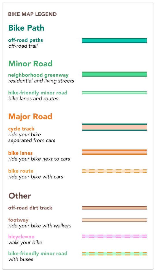
Mapzen's Bike Map (read blog post) uses OpenStreetMap tags and relations to color roads and paths according to their (relative) safely. See legend at right.
The OpenStreetMap tag rendering logic is in the Walkabout repo (view source).
This GIST is a human readable version:
- highway =
cycleway, or - highway =
path,pedestrian, orsteps, and one of the following:- bicycle: [
yes,designated], or - member of bicycle route relation
- bicycle: [
Note that this styling is not live yet, but based on comments since the bike map was published.
- highway =
living_streetorunclassified, and one of the following:- cycleway =
shared_lane, or - bicycle =
yesordesignated, or - member of bicyle route relation
- cycleway =
- highway =
track, and one of the following:- bicycle =
yesordesignated, or - member of bike route relation
- bicycle =
- highway =
footwayorsteps, and one of the following:- bicycle =
yesordesignated, or - member of bike route relation
- bicycle =
- Any highway tag, and
- cycleway =
lane,opposite, oropposite_lane, or - cycleway_left:
lane,opposite, oropposite_lane, or - cycleway_right:
lane,opposite,opposite_lane
- cycleway =
- Any highway tag, and
- cycleway =
sidepath,track,opposite_track,buffered_lane, or - cycleway_left:
sidepath,track,opposite_track,buffered_lane, or - cycleway_right:
sidepath,track,opposite_track,buffered_lane
- cycleway =
- Any highway tag, and
- bicycle =
yesordesignated, or - member of bicycle route relation
- bicycle =
- highway =
service,residential,unclassified,living_street,track,path,footway, orsteps, and one of the following:- bicycle =
noordismount
- bicycle =
![]()
The bike map has special icon treatments for the following, based on Tilezen kind values:
- bicycle_parking kind, sourced from OpenStreetMap's:
- amenity =
bicycle_parking
- amenity =
- bicycle_rental
- amenity =
bicycle_rental
- amenity =
- bicycle_rental_station
- amenity =
bicycle_rental, and - operator = any value
- amenity =
- bicycle store / repair
- shop =
bicycle
- shop =
- bicycle_junction
- icn_ref = any value, or
- ncn_ref = any value, or
- rcn_ref = any value, or
- lcn_ref = any value
- toilets
- amenity =
toilets
- amenity =
- drinking_water
- amenity =
drinking_water
- amenity =
- cafe
- amenity =
cafe
- amenity =
- pub
- amenity =
pub
- amenity =
- cycle_barrier
- barrier =
cycle_barrier
- barrier =
@nvkelso awesome, thanks for the link! Actually doing more research I could use that cycling map through Tangram Play which fortunately wasn't shutdown neither :)
And yea, sorry for that error, OpenBikeMap is still in its very early stages...