Skip to content

Instantly share code, notes, and snippets.

View planemad's full-sized avatar

Arun Ganesh planemad

View GitHub Profile
@planemad
planemad / nid-map-design-workshop.md
Last active August 29, 2015 14:15
Intermediate map design workshop

Objective: Make students comfortable with creating interactive map based visualizations that can be used in their projects.

Tool chain: mapbox editor > overpass-turbo > openstreetmap > geojson.io > mapbox studio (download) > github pages > mapbox.js > turf.js

Duration: 16 hours (3 days)

Schedule

Background Tasks

  • Participants can explore existing maps and geo visualizations on the web and select one of choice that interests them.
@planemad
planemad / short-gis-workshop.md
Last active August 29, 2015 14:16
Short GIS workshop

Objective: Make particpants understand how to use openstreetmap data in their GIS projects and to leverage its value using custom cartography and web interactivity.

Tool chain: Openstreetmap > Overpass-turbo > Mapbox Studio (download) > Mapbox.js > Turf.js

Duration: 2 hours

Schedule

Background Tasks

  • Signup with Mapbox using your .edu email
@planemad
planemad / india-place-language.md
Last active October 19, 2022 18:04
The language of Indian places

India, as is already well known, is a complex universe. The 1.2 billion people who inhabit an area 1/3rd the area of the US speak over 1000 native tongues. There are 2 official languages in use by the federal government for administration - English and Hindi. The Indian Union gives special status to 22 scheduled languages which are considered the major regional languages, each with many millions of native speakers. These 22 languages are what can be practically considered the major languages of India that will cover over 95% of the population.

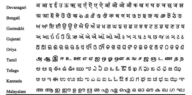
To take complexity to the next level, there are 9 writing systems that are exclusively found only in India and are in active use for their respective languages. While most scheduled languages have their dedicated writing system, other languages have adopted a writing system like the case of [Konkani](https://en.wikipedia.o

@planemad
planemad / studio-exercise.md
Last active August 29, 2015 14:19
Studio Exercise

Studio Exercise

Use the Mapbox Studio Guides for reference.

1: Introduction

  • Create a new style project using the Basic style
  • Change the color of the land to black
  • Change the color of water to lighten(@land,50%)
  • Change color of roads to red
  • Brighten the color of place names so that they are visible
  • Show names of places only after zoom level 7

Nepal HOT Validation: Road Network for Routing

High quality maps is critical to field work. Experienced mappers may validate existing data to fix serious errors and invalidate an area for further work.

Task Briefing

Review the work of existing mappers using the HOT Task Manager. Our priority is routing and we will focus on Road network tasks 1,2,3,6. Pick and unreviewed area and throughly examine the area for the following issues:

Incomplete/Low quality Task If there are numeruous roads missing and requires a lot more work to improve the quality, /invalidate this task/ so that others can continue to improve it. Add a comment clearly describing the reason for invalidating and what areas needs improvement.

Isolated Segments

Fixing India border on mapbox-streets style using Mapbox Studio Classic

  • Add Indian disputed boundaries source: planemad.bb1ba8b5 to your style project from the layers panel
  • If the source is locked, open the project.yml file and append it manually to the source field. You would also need to manually add the layers boundaries-claimed and boundaries-disputed after the admin layer similiar to this:
source: "mapbox:///mapbox.mapbox-terrain-v2,mapbox.mapbox-streets-v6,planemad.bb1ba8b5"
layers:

  • Enable your home folder from your Finder preferences>Sidebar section

  • From Finder, browse to your home folder and Goto View>Show View Options or Cmd+Shift+J and enable the Show Library Folder option
@planemad
planemad / gist:5d8cd7dd885048341458
Last active August 29, 2015 14:24
Mapping roads

Mapping roads

A road is a thoroughfare, route, or way on land between two places that has been paved or otherwise improved to allow travel by some conveyance, including a horse, cart, bicycle, motor vehicle or foot - Wikipedia

Roads are one of the most useful features of a map, as they help us find the best travel path between any two points based on our preferences.

Find the shortest driving route Khanpur to Rajanpur. Assume your car cannot swim. untitled

Sorry, something went wrong. Reload?
Sorry, we cannot display this file.
Sorry, this file is invalid so it cannot be displayed.

Introduction to GIS

The world is not flat

Projection

  • Cylindrical: Mercator WGS84, Web Mercator
  • Azimuthal
  • Conical