-
Star
(245)
You must be signed in to star a gist -
Fork
(23)
You must be signed in to fork a gist
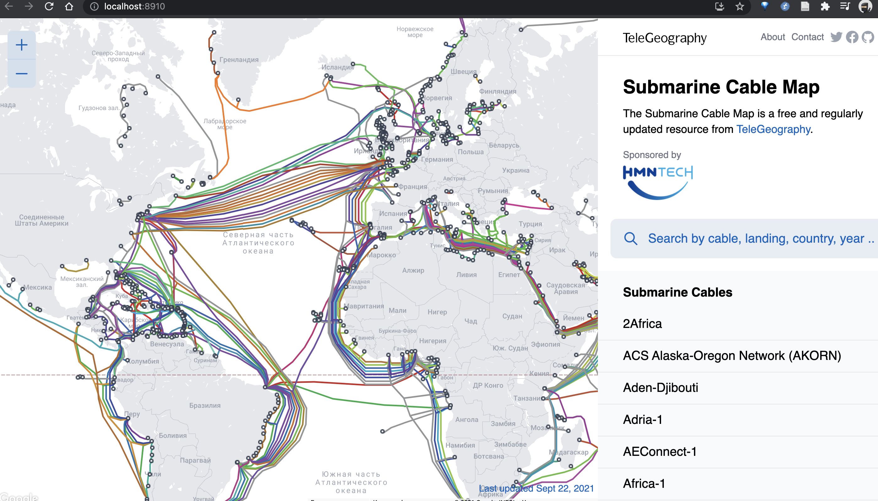
| library(geojsonsf) | |
| library(sf) | |
| library(rayrender) | |
| #Data source: https://github.com/telegeography/www.submarinecablemap.com | |
| cables = geojson_sf("cable-geo.json") | |
| cablescene = list() | |
| counter = 1 | |
| for(i in 1:length(cables$geometry)) { | |
| for(j in 1:length(cables$geometry[[i]])) { | |
| temp = cables$geometry[[i]][[j]] | |
| cableval = data.frame(x=sinpi(temp[,1]/180)*cospi(temp[,2]/180), | |
| y=sinpi(temp[,2]/180), | |
| z=cospi(temp[,1]/180)*cospi(temp[,2]/180)) | |
| #Don't lower start of line at the 180/0 longitude border | |
| if(abs(temp[1,1] - 180) > 0.001 && abs(temp[1,1] + 180) > 0.001) { | |
| cableval[1,] = cableval[1,] * 1/1.02 | |
| } | |
| nr = nrow(temp) | |
| #Don't lower end of line at the 180/0 longitude border | |
| if(abs(temp[nr,1] - 180) > 0.001 && abs(temp[nr,1] + 180) > 0.001) { | |
| nr = nrow(cableval) | |
| cableval[nr,] = cableval[nr,] * 1/1.02 | |
| } | |
| cablescene[[counter]] = path(cableval, width = 0.005,material=diffuse(color=cables$color[i])) | |
| counter = counter + 1 | |
| } | |
| } | |
| fullcablescene = do.call(rbind,cablescene) | |
| for(i in seq(1,720,by=1)) { | |
| group_objects(fullcablescene,scale=c(1,1,1)*1.02) %>% | |
| add_object(sphere(radius=0.99,material=diffuse(image_texture = "2k_earth_daymap.jpg"),angle=c(0,-90,0))) %>% | |
| group_objects(angle=c(0,-i/2,0)) %>% | |
| add_object(sphere(y=5,z=5,x=5,material=light(intensity = 80,color="lightblue"))) %>% | |
| add_object(sphere(y=5,z=5,x=-5,material=light(intensity = 10,color="orange"))) %>% | |
| add_object(sphere(y=-10,material=light(intensity = 3,color="white"))) %>% | |
| render_scene(samples=64,width=1200,height=1200,fov=0,aperture=0, ortho_dimensions = c(2.3,2.3), | |
| sample_method = "sobol_blue",filename=sprintf("smallcables%d.png",i)) | |
| } |
Hi,
I was wondering if anyone still had access to a repo of the Telegeography submarine cable map. They no longer maintain their public github as of 2 weeks ago, and I wanted to look at their source code. Thank you!
I was looking for it as well, I think you get it from the attachments here,
https://observablehq.com/@ariellemartinez/submarine-cable-map
Good Luck!
I have consolidated and modified a little there :
Some pointers for beginners to R:
- You'll need three R packages: "geojsonsf", "sf", and "rayrender"
- "sf" expects some libraries to be installed on your system, see its readme on how to do this, for example for Linux
- You'll need a Fortran compiler. If you're on Arch Linux:
pacman -S gcc-fortran - After installing R and opening its command line, install the packages with
install.packages(c("geojsonsf", "sf", "rayrender")) - Then run the script with
source("submarine_cable_map.R")
I'm offering the PNGs of the cable map via the following torrent magnet link since rendering them can take a few hours, depending on your hardware:
magnet:?xt=urn:btih:d3d832c365c5f7ec88d0bea1a4d3906a064950f9&dn=submarine_cables_map_pngs
Turn the PNGs into a video using, for example:
ffmpeg -i smallcables%03d.png -vf scale=720:720 -crf 55 globe.webmffmpeg -i smallcables%03d.png -vf scale=720:720 -pix_fmt yuv420p -crf 26 globe.mp4
Reduce the value of -crf for higher quality or set the resolution to something else, for example: scale=1024:1024
cables = geojson_sf("cable-geo.json")
"Error in rcpp_geojson_to_sf(geojson, expand_geometries) : Invalid JSON"I guess that you're supposed to do the installation of the cable map first as described here, but after doing so, how do I export this map into a .json file like you did ("cable-geo.json")?
EDIT: oh boy it was all simple I was supposed to just download & save a file linked here

Hey ! If available, can you please send me the dataset for the cables-map, unfortunately telegeography stopped maintaining their public github repo for downloads. Would really like to work on this dataset. If anyone can help, i would really appreciate the support !
The Internet Archive is your friend. https://web.archive.org/web/20220325102119/https://github.com/telegeography/www.submarinecablemap.com
https://www.submarinecablemap.com/api/v3/cable/cable-geo.json https://www.submarinecablemap.com/api/v3/landing-point/landing-point-geo.json https://www.submarinecablemap.com/api/v3/cable/all.json
Does anyone know if this API is maintained and up-to-date?
https://www.submarinecablemap.com/api/v3/cable/cable-geo.json https://www.submarinecablemap.com/api/v3/landing-point/landing-point-geo.json https://www.submarinecablemap.com/api/v3/cable/all.json
Does anyone know if this API is maintained and up-to-date?
These json files are used to plot https://www.submarinecablemap.com as can be seen from browser developer tools, so I'm assuming it should be up-to-date and consistent with the website?
The SFU link for the JPG doesn't work, here's the wikimedia source file.
https://upload.wikimedia.org/wikipedia/commons/c/c3/Solarsystemscope_texture_2k_earth_daymap.jpg