#remotes::install_cran(c("anglr", "silicate"))
library(silicate)
library(anglr)
library(rgl)
## volcano is heightmap, doesn't exist in geo-space in R so we map it do the extent of
## these spatial polygons
poly <- silicate::minimal_mesh
# xmin : 0
# xmax : 1.23
# ymin : 0
# ymax : 1
## arbitrarily drape polygons over raster
hmap <- raster::setExtent(raster::raster(volcano), raster::extent(0, 1.23, 0, 1))
## use DEL0 so we can control triangle area (not possible with decido, without
## post-hoc subdivision)
triangles <- copy_down(DEL0(poly, max_area = 0.001), hmap)
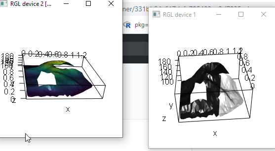
mesh1 <- as.mesh3d(triangles)
open3d();plot3d(mesh1)
aspect3d(1, 1, 0.5)
# that was just polygons + raster, so now make an image from the raster and
# texture it on (this could be a photograph, a map, just needs to be a 3-layer RGB raster)
im <- palr::image_raster(hmap, col = viridis::viridis(32))
mesh2 <- as.mesh3d(triangles, image_texture = im)
open3d(); plot3d(mesh2)
aspect3d(1, 1, 0.2)
Created
May 20, 2020 09:18
-
-
Save mdsumner/331bb94c617dcfe705400ee3d7825ccb to your computer and use it in GitHub Desktop.
Author
mdsumner
commented
May 20, 2020
Sign up for free
to join this conversation on GitHub.
Already have an account?
Sign in to comment